Monday, March 30, 2015

Colorful fish of Port au Prince = invasive guppies!

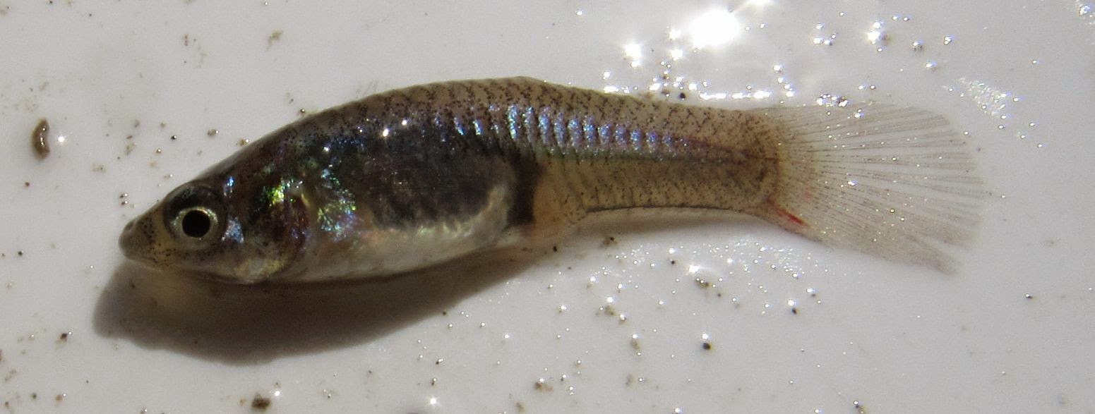
The canals running along the streets of Port au Prince are trashy and look like disgusting cesspools, but we sampled one along Mais Gate to see what fish were there.  A spring flows into this canal after running down a side street.  The colorful little fish living there were quite surprising.  Further investigation revealed they are guppies!  Dr. Helen Rodd (see her lab website) confirmed this, saying their coloration indicates they "have some fancy, domesticated guppies in their ancestry."

Guppies are in the same family Poeciliidae as the endemic Gambusia and Limia, which means they could out compete these native species if they ended up in Haiti's streams and lakes.


Female


We sampled in the cattails in the canal.

Releasing the fish back into the canal.

Yes, fish live here!
Clear spring water running down the street that comes out at Mais Gate.


Saturday, March 28, 2015

Examination of Riviere Lislet Les Cayes Haiti

The short study of Riviere Glace was followed by a brief examination of Riviere Lislet that runs south along the eastern edge of Les Cayes before ending at the ocean.  We sampled where Rue Simon crosses the river, and arrived before the area was too busy with people washing themselves, laundry, and motos.  The water was warmer and siltier than Riviere Glace, but we found a lot of the native mosquito fish (Gambusia) and small tilapia (non-native fish).  The young men there were very eager to help us find fish and macroinvertebrates.

Sample date 24 March 2015 7:30am
Temperature = 26.27C                   pH = 8.04             turbidity = 0 NTU
Dissolved oxygen = 6.85 mg/l     oxygen reduction potential = 89 mV
Conductivity = 0.387 mS/cm    salinity = 0.02%                 total dissolved solids = 0.252 g/l

E. coli bacteria 3 colonies in 1 ml water (see the test kit here)

Water quality measurements were taken upstream of Rue Simon crossing.

Looking upstream.
  
Native mosquito fish Gambusia

Freshwater shrimp

Monday, March 23, 2015

Biodiversity of Riviere Glace

Riviere Glace is a beautiful river than runs near the village of Duchity, a town about an hour's drive north of Les Cayes Haiti.  Along the river the highway is being widened and paved, and right before Duchity there is a new bridge.  Stop at this bridge and hike upstream along and through the river about 100 m and at a bend in the river you will come to a series of clear cool pools perfect for swimming on a hot day.  Unfortunately the road construction along this stretch threatens this pristine river.  Here are some photos of what the area looked like on 22 March 2015.

Sample time 9:50am
Temperature = 20.41 C           pH = 6.58             turbidity = 0 NTU
Dissolved oxygen= 11.54 mg/l     oxygen reduction potential = 187 mV
Conductivity = 0.212 mS/cm       salinity = 0.01%                 total dissolved solids = 0.252 g/l

No E. coli or coliform bacteria (see the test kit here)


Epilobocera haytensis Rathbun, 1893

Deep pool at the bend (note the gabion) and riffles upstream (no gabion).

Gabion at the bridge.

Mayfly larvae on a rock in the river.

The deep pool at the bend in the river.

Two tadpoles and a damselfly larvae.

The view upstream from the pool.  Road-side bank is on the left and has no gabion.

View walking upstream from the bridge.  Note the calf (with mom) by the river!

Wednesday, March 18, 2015

Possible invasive hibicus of Etang Douat, Haiti

While evaluating the watershed of Etang Douat, a currently dry lake in the southern peninsula of Haiti, we came across this dense patch of thorny hibiscus growing in the dry lake bed.  Ani’s (black birds called boustabek in Creole) were hanging out in the patch.  If anyone has any ideas about what it is, please leave a comment, or email me at debbieauc at gmail.com.


Tuesday, March 17, 2015

Asian carp of Etang Laborde, Haiti

Researchers from the University of Kansas are in Haiti studying the watersheds of Etang Lachaux, Douat, and Laborde, 3 lakes between Camp Perrin and Les Cayes on the southern peninsula.  We heard reports of a large fish called the bout lang that used to be found in Etang Lachaux.  The older residents remembered it from their childhood, and indicated it was about a meter long.  We weren't sure if it was just a tall fish tale until we saw it at Etang Laborde!  A fisherman had caught it and was standing with it by the road as we were leaving Laborde.  It was 78 cm long, and here are pictures.  Further investigation revealed that this is the introduced silver carp Hypophthalmichthys molitrix.  Residents said it was released in 1977.


Monday, March 2, 2015

Analyse-diagnostic des versants qui surplombent l’étang Laborde

In 2007 Louis-Jean Enold performed a study of the watershed of Etang Laborde, a lake 10 miles north of Les Cayes, Haiti.  This report has excellent information about the life of the people and flora and fauna of the watershed.  Click to download the pdf.

Analyse-diagnostic des versants qui surplombent l’étang Laborde

Resume
Cette étude se porte sur les versants qui surplombent l’étang Laborde, l’une des zones humides les plus importantes de la commune des Cayes. Elle se donne pour objectif de diagnostiquer ces versants et de proposer des alternatives d’exploitation plus appropriées conduisant à une gestion durable des ressources du milieu. Ainsi, une approche historique et une approche systémique ont été utilisées. Nous avons mené des enquêtes préliminaires sur une population de soixante-dix (70) exploitants agricoles répartis dans sept localités de la zone d’étude. De ces derniers, un échantillon plus restreinte de trente-deux (32) exploitants, choisis au hasard, , a été retenu pour des enquêtes approfondies. Les résultats montrent que les risques d’érosion sont élevés pour environ 66% et grave pour près de 5% des terres du bassin versant qui couvre 711.27 ha. Ainsi, seulement 1.40% soit 9.96 ha a de très bonnes potentialités. Quant à la couverture forestière, elle est très réduite. Nous avons pu en distinguer une couverture dense (16.36%), une couverture éparse (11.97%) et une couverture déboisée qui occupe la plus grande partie du bassin versant soit (71.97%). Des 54.17 ha exploités par nos enquêtés 70.06% sont en FVD 29.74% en FVI. La surface totale par exploitation varie de 0.33 à 3.73 ha avec une moyenne de 1.71 ha.